
- Česky (cs)
- English (en)
Langweil model of Prague
This page offers a high quality scientific data for a 3D digital reconstruction of Langweil model of Prague. It is primarily oriented towards research groups and individuals who are wishing to check their reconstruction algorithms on the real data and compare results with existing 3D model(s).
Overview
Model description
The oldest model of Prague was created by Antonín Langweil in years 1826 - 1837 and is placed at City of Prague Museum. It is made of paper and illustrated by pen-and-ink drawings. The model size is about 3.5m x 6m in scale 1:480, corresponding area of the real city is about 1.6km x 2.6km. There are more than 2000 buildings corresponding to land register and almost 7000 other unique objects like shelters, small walls, statues, and trees. The ground varies throughout the city. The Old Town is mainly planar going down to the Vltava river and then to the hilly part of Prague, the Prague Castle and gardens around. The model itself consists of 57 parts, each with diferent number of objects and a complexity, see Fig. 1.
 |
| Fig. 1: From left to right: Langweil model of Prague at City of Prague Museum, one model part, detail photo - a wall with millimetre ruler. |
Purpose of this page
| A huge number of photos was acquired during the digitisation of the Langweil model. All photographs are the property of the City of Prague Museum. Three photo sets, corresponding to 3 different parts of Langweil model, are afforded on this page for scientific purposes under the City of Prague Museum permition. The data sets are provided for free after submision of registration form. See Registration section. | |
Available data
| Part number | Image | Photos count | Description |
|---|---|---|---|
| 09 |  | 386 | Small, compact piece. It is suitable for study of 3D reconstruction algorithms. Terrain: flat |
| 08 |  | 980 | More exacting piece, with streets and complex geometry. Dealing with current state-of-the-art in 3D reconstruction. Terrain: flat |
| 27 |  | 5938 | This piece contains a lot of occlusions caused by terrain variations and a huge number of trees. Suitable for the most robust algorithms testing. Terrain: hilly, a lot of rough surfaces |
For each of the above data sets, we provide:
- Originally obtained RAW photos (4K resolution, 13-bits per channel),
- MySQL database with additional information about photos,
- The reconstructed 3D models in the VRML format with PNG textures.


Registration
- Download an appropriate language version of the registration form (Statutory Declaration):
- Fill, Print, Sign, and Scan the form.
- Submit the form (2 pages) via e-mail to langweil3d@muzeumprahy.cz.
Please, be patient - the processing of your request/form in the City of Prague Museum usually takes about a week. Then you will be informed via e-mail about the access to the data.
Related papers
- David Sedlacek and Jiri Zara. The Langweil model of Prague - a challenge for state-of-the-art 3D reconstruction techniques. Poster on Eurographics 2011. bib poster and paper together
- David Sedlacek and Jiri Zara. Graph cut based point-cloud segmentation for polygonal reconstruction. In Advances in Visual Computing (ISVC 2009), Lecture Notes in Computer Science, 2009, Volume 5876/2009, pp. 218-227 URL
Other links
- The Digitisation of Langweil Model Of Prague - main project web page.
- City of Prague Museum - the place where the original paper model can be seen.
- Walk through in VRML - BSContact browser required.
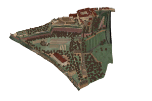
 |
| Fig. 2: The whole reconstructed model |
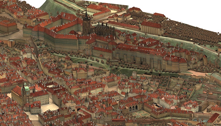 |
| Fig. 3: The whole reconstructed model in closer detail near Prague Castle |
